| This map is found on Mapicurious.com | Download these points of interest directly into your favorite GPS or other geo software | |||
|
|||
| Use the zoom controls on the map to adjust the map's viewable area then print: | |||
| LOCATIONS highlighted on this map: |
|
lat:33.8849833 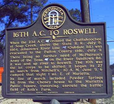
When the 23d A.C. [US] crossed the Chattahoochee at Soap Creek, above the State R. R., July 8, 1864, Johnston's River Line [CS] (Oakdale Rd.) was evacuated to the Fulton County side, July 9. There being no further need of McPherson's Army of the Tenn. [US] on the lower Sandtown Rd., it was sent up river to Roswell. The 16th was the 1st corps to be shifted; it began its 27 mi. march from Mitchell's, 10 A. M. June 9, & camped that night 1 mi. E. of Marietta. Its line of march included Powder Springs Rd. from the Cheney house to the Marietta Public Square, traversing, enroute the battlefield of Kolb's Farm.033-60 GEORGIA HISTORICAL COMMISSION 1954
lat:33.950683 Click the link for pictures of Cobb County markers.
lat:34.0022833 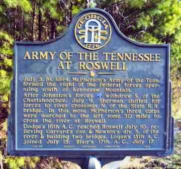
July 3, 16, 1864. McPherson's Army of the Tenn. formed the right of the Federal forces operating south of Kennesaw Mountain.After Johnston's forces [CS] withdrew S. of the Chattahoochee, July 9, Sherman shifted his forces to river crossings N. of the State R. R. bridge. In this move McPherson's three corps were marched to the left some 30 miles to cross the river at Roswell.Dodge's 16th A.C. reached Roswell July 10, relieving Garrard's cav. & Newton's div. S. of the river & building two bridges. Logan's 15th A. C. joined July 15; Blair's 17th A. C., July 17033-95 GEORGIA HISTORICAL COMMISSION 1954
lat:33.910380 
lat:33.905786 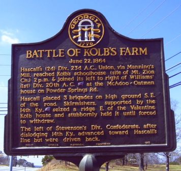
Hascall's (2d) Div., 23d A.C., Union, via Manning's Mill, reached Kolb's schoolhouse (site of Mt. Zion Ch.) 2 p.m. and joined its left to right of William's (1st) Div., 20th A.C. (F) at the McAdoo?Oatman house on the Powder Springs Rd. Hascall placed 3 brigades on high ground S.E. of the road. Skirmishers supported by the 14th Ky. (F) seized a ridge E. of the Valentine Kolb house and stubbornly held it until forced to withdraw. The left of Stevenson's Div. (C), after dislodging 14th Ky., advanced toward Hascall's line but were driven back.
lat:33.910366 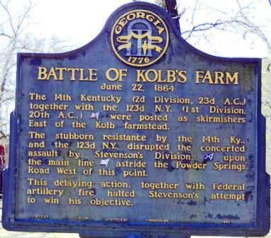
lat:33.910394 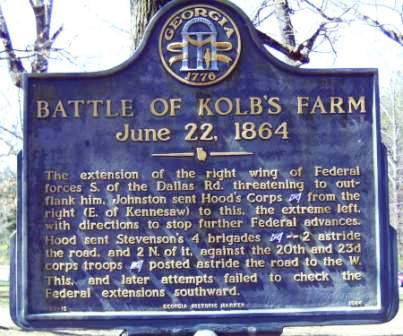
lat:33.904976 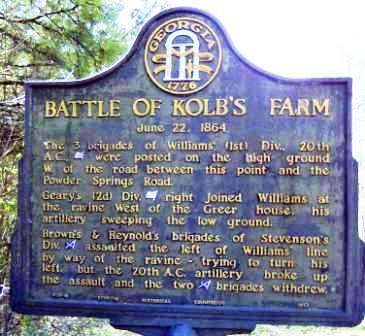
lat:34.0238 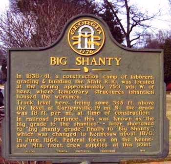
In 1838-41, a construction camp of laborers, grading & building the State R. R., was located at the spring approximately 250 yds. W. of here, where temporary structures (shanties) housed the workmen.Track level here, being some 345 ft. above the level at Cartersville, 19 mi. N., the grade was 18 ft. per mi. at time of construction. In railroad parlance, this was known as "the big grade to the shanties" -- later shortened to "big shanty grade", finally to "Big Shanty", which was changed to Kennesaw about 1870.In June, 1864, Federal forces on the Kennesaw Mtn. front, drew supplies at this point.033-40 GEORGIA HISTORICAL COMMISSION 1954
lat:33.9454833 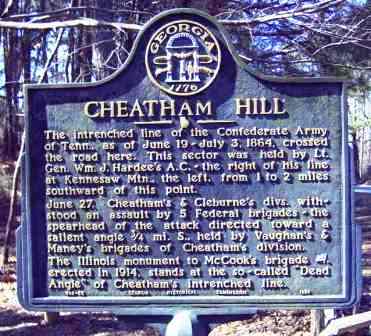
The intrenched line of the Confederate Army of Tenn., as of June 19-July 3, 1864, crossed the road here. This sector was held by Lt. Gen. Wm. J. Hardee's A.C. -- the right of his line at Kennesaw Mtn., the left, from 1 to 2 miles southward of this point.June 27. Cheatham's & Cleburne's divs. withstood an assault by 5 Federal brigades -- the spearhead of the attack directed toward a salient angle 3/4 mi. S., held by Vaughan's & Maney's brigades of Cheatham's division.The Illinois monument to McCook's brigade [US], erected in 1914, stands at the so-called "Dead Angle" of Cheatham's intrenched line. 033-55 GEORGIA HISTORICAL COMMISSION 1954
lat:33.945879 
lat:33.9527667 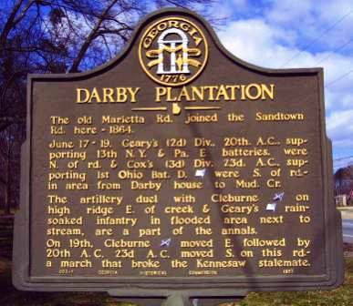
The old Marietta Rd. joined the Sandtown Rd. here -- 1864.June 17-19. Geary's (2d) Div., 20th A.C., supporting 13th N.Y. & Pa. E batteries, were N. of rd. & Cox's (3d) Div. 23d. A.C., supporting 1st Ohio Bat. D. [US] were S. of rd. -- in area from Darby house to Mud Cr.The artillery duel with Cleburne [CS] on high ridge E. of creek & Geary's [US] rain-soaked infantry in flooded area next to stream, are a part of the annals.On 19th, Cleburne [CS] moved E. followed by 20th A.C. 23d A.C. moved S. on this rd. -- a march that broke the Kennesaw stalemate.033-7 GEORGIA HISTORICAL COMMISSION 1952
lat:33.9862333 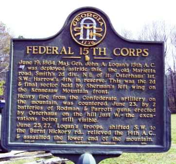
June 19, 1864. Maj. Gen. John A Logan's 15th A. C. [US] was deployed astride this, the old Marietta road; Smith's 2d div., N. E. of it; Osterhaus' 1st, S. W.; Harrow's 4th, in reserve. This was the 2d & final sector held by Sherman's left wing on the Kennesaw Mountain front.Heavy fire from the Confederate artillery on the mountain, was countered, June 23, by 2 batteries of Rodman & Parrott guns, erected by Osterhaus on the hill just W. -- the excavations being still visible.June 25, 27. Logan's troops, shifted S. W. to the Burnt Hickory rd., relieved the 14th A. C., & assaulted the lower end of the mountain.033-49 GEORGIA HISTORICAL COMMISSION 1954
lat:33.9449333 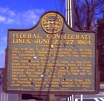
One-half mi. S., at the road - fork, is SIGNAL HILL, where Sherman observed the assault on Cheatham Hill by troops of the 4th & 14th Corps [Union], June 27.The John Ward Road -- left turn at the fork -- leads to Thomas' Headquarters, June 27, & the battlefield of Kolb's Farm, on & near Powder Springs road, 2.5 mi. S., where Hood [Confed.] attacked the right of the 20th & the left of the 23d Corps [Union], June 22.The road W. leads to Dallas & New Hope Ch., in Paulding County, where Federal & Confederate forces were in daily conflict 10 days.033-56 GEORGIA HISTORICAL COMMISSION 1954
lat:34.0238 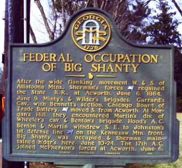
After the wide flanking movement W. & S. of Allatoona Mtns., Sherman's forces [US] regained the State R. R., at Acworth, June 6, 1864.June 9. Minty's & Wilder's brigades, Garrard's Cav., with Bennett's section, Chicago Board of Trade Battery, [US] moved S. from Acworth. At Morgan's Hill, they encountered Martin's div. of Wheeler's cav. & Benton's brigade. Hood's A.C. Benton & Martin withdrew S. E. to Johnston's 1st defensive line [CS] on the Kennesaw Mtn. front. Big Shanty was occupied & Sherman maintained h'dqr's. here, June 10-24. The 17th A. C. joined McPherson's forces at Acworth, June 6.033-43 GEORGIA HISTORICAL COMMISSION 1954
lat:33.95225 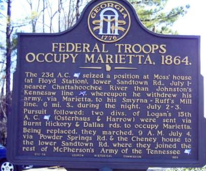
The 23d A.C. [US] seized a position at Moss' house (at Floyd Station), lower Sandtown Rd., July 1 -- nearer Chattahoochee River than Johnston's Kennesaw line [CS], whereupon he withdrew his army, via Marietta, to his Smyrna - Ruff's Mill line, 6 mi. S., during the night, July 2-3.Pursuit followed; two divs. of Logan's 15th A.C. [US] (Osterhaus & Harrow) were sent via Burnt Hickory & Dallas rds. to occupy Marietta. Being replaced, they marched, 9 A.M. July 4, via Powder Springs Rd. & the Cheney house to the lower Sandtown Rd. where they joined the rest of McPherson's Army of the Tennessee [US].033-54 GEORGIA HISTORICAL COMMISSION 1954
lat:33.95225
The 23d A.C. [US] seized a position at Moss' house (at Floyd Station), lower Sandtown Rd., July 1 -- nearer Chattahoochee River than Johnston's Kennesaw line [CS], whereupon he withdrew his army, via Marietta, to his Smyrna - Ruff's Mill line, 6 mi. S., during the night, July 2-3.Pursuit followed; two divs. of Logan's 15th A.C. [US] (Osterhaus & Harrow) were sent via Burnt Hickory & Dallas rds. to occupy Marietta. Being replaced, they marched, 9 A.M. July 4, via Powder Springs Rd. & the Cheney house to the lower Sandtown Rd. where they joined the rest of McPherson's Army of the Tennessee [US].033-54 GEORGIA HISTORICAL COMMISSION 1954
lat:33.9334167 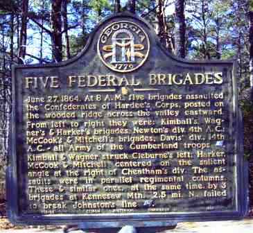
June 27, 1864. At 8 A. M., five brigades assaulted the Confederates of Hardee's Corps, posted on the wooded ridge across the valley eastward. From left to right there were: Kimball's, Wagner's & Harker's brigades, Newton's div. 4th A. C.; McCook's & Mitchell's brigades, Davis' div., 14th A. C. -- all Army of the Cumberland troops [US]. Kimball & Wagner struck Cleburne's left; Harker, McCook & Mitchell centered on the salient angle at the right of Cheatham's div. The assaults were in parallel regimental columns. These & similar ones, at the same time, by 3 brigades at Kennesaw Mtn. 2.5 mi. N., failed to break Johnston's line [CS].033-58 GEORGIA HISTORICAL COMMISSION 1954
lat:33.9451667 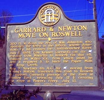
300 ft. W. stood the res. of Wm. Johnston who operated the ferry in the 1850's, where Johnston's Fy. Rd. crosses the Chattahoochee River.July 5, 1864. Gen. Kenner Garrard's cav. div. [US] enroute from Marietta to Roswell via this rd., camped on Willeo Cr., from which point he sent a regiment S. to burn the Paper Mills on Soap Creek.July 9. Newton's 4th A. C. div. [US], moving from Vining's Station, traversed this road to Roswell to support Garrard's passage of the river at Shallow Ford -- retracing July 12 & crossing the river at Power's Ferry, July 13.033-93 GEORGIA HISTORICAL COMMISSION 1963
lat:33.9917167 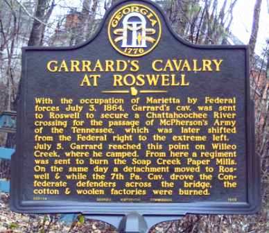
With the occupation of Marietta by Federal forces July 3, 1864, Garrard's cav. was sent to Roswell to secure a Chattahoochee River crossing for the passage of McPherson's Army of the Tennessee, which was later shifted from the Federal right to the extreme left.July 5. Garrard reached this point on Willeo Creek, where he camped. From here a regiment was sent to burn the Soap Creek Paper Mills. On the same day a detachment moved to Roswell & while the 7th Pa. Cav. drove the Confederate defenders across the bridge, the cotton & woolen factories were burned.044-94 GEORGIA HISTORICAL COMMISSION 1963
lat:33.9320833 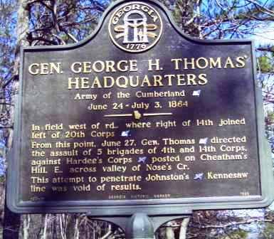
n field west of rd., where right of 14th joined left of 20th corps [US].From this point, June 27, Gen. Thomas [US] directed the assault of 5 brigades of 4th and 14th Corps, against Hardee's Corps [CS] posted on Cheatham's Hill, E., across valley of Nose's Cr.This attempt to penetrate Johnston's [CS] Kennesaw line was void of results.033-15 GEORGIA HISTORIC MARKER 1985
lat:33.96405 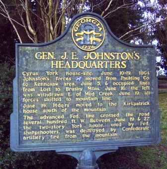
Cyrus York house-site; June 10-19, 1864. Johnston's forces [CS] moved from Paulding Co. to Kennesaw area, June 5, & occupied lines from Lost to Brush Mtns. June 16: the left was withdrawn E. of Mud Creek. June 19: all forces shifted to mountain line. June 19: Hdq'rs moved to the Kirpatrick house south of the mountain.The advanced Fed. line crossed the road several hundred ft. W. Between June 19 & 27, the two-story York house, used by Fed. sharpshooters, was destroyed by Confederate artillery fire from the mountain.033-18 GEORGIA HISTORICAL COMMISSION 1953
lat:33.9641 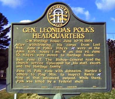
G.W. Hardage house; June 10-14, 1864After withdrawing his corps from Lost Mtn. June 9, Polk's H'dq'rs. [CS] were at the John Kirk house 1 mi. W. on this rd. June 10, h'dq'rs. were moved to Hardage house. Sun. June 12. The Bishop-General read the church service (Episcopal) for his staff, escort, and the Hardage family.June 14. Polk rode with Johnston, Hardee & others to Pine Mtn. to inspect Bate's [CS] line at that advanced outpost. While there, Polk was killed by a Federal shell. 033-20 GEORGIA HISTORICAL COMMISSION 1953
lat:33.9633333 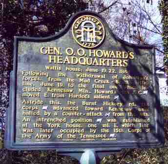
Wallis house; June 19, 22, 1864Following the withdrawal of Johnston's forces, from the mud Creek -- Brushy Mtn. line, June 19, to the final one, which included Kennesaw Mtn., Howard's 4th A. C. [US] moved E. from Hardee's salient [CS]. Astride this, the Burnt Hickory rd., the corps [US] advanced toward Kennesaw until halted by a counter-attack [CS] from the mtn. An intrenched position [US] was established at the York house, one mi. E. which line was later occupied by the 15th Corps of the Army of the Tennessee [US]. 033-21 GEORGIA HISTORICAL COMMISSION 1953
lat:33.9809333 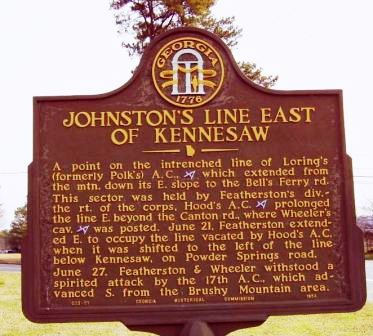
A point on the intrenched line of Loring's (formerly Polk's) A.C., [CS] which extended from the mtn. down its E. slope to the Bell's Ferry rd. This sector was held by Featherston's div. -- the rt. of the corps, Hood's A.C. [CS] prolonged the line E. beyond the Canton rd., where Wheeler's cav. [CS] was posted. June 21, Featherston extended E. to occupy the line vacated by Hood's A.C. when it was shifted to the left of the line below Kennesaw, on Powder Springs road.June 27. Featherston & Wheeler withstood a spirited attack by the 17th A.C., which advanced S. from the Brushy Mountain area.033-51 GEORGIA HISTORICAL COMMISSION 1954
lat:33.96335 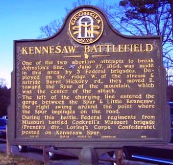
One of the two abortive attempts to break Johnston's line, [CS] June 27, 1864, was made in this area by 3 Federal brigades. Deployed on the ridge W. of the stream & astride Burnt Hickory rd., they moved E. toward the Spur of the mountain, which was the center of the attack. The left of the charging line entered the gorge between the Spur & Little Kennesaw; the right swung around the point where the Spur impinges on the road.During this battle, Federal regiments from Missouri battled Cockrell's Missouri brigade (French's div., Loring's Corps, Confederate), posted on Kennesaw Spur.033-52 GEORGIA HISTORICAL COMMISSION 1954 |


|
Although the author has taken all reasonable care in preparing this guide, Mapicurious and the author make no warranty about the accuracy or completeness of its content and accept no responsibility for any loss, injury, or inconvenience arising from its use. |