| This map is found on Mapicurious.com | Download these points of interest directly into your favorite GPS or other geo software | |||
|
|||
| Use the zoom controls on the map to adjust the map's viewable area then print: | |||
| LOCATIONS highlighted on this map: |
|
lat:39.46952778 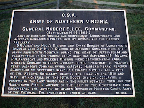
lat:39.4695 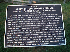
lat:39.47525 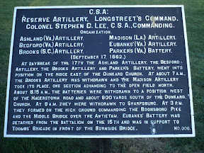
lat:39.47569444 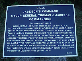
lat:39.44730556 
lat:39.48097222 
lat:39.47852778 
lat:39.48108333 
lat:39.48122222 
lat:39.48133333 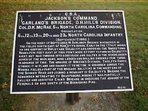
lat:39.45155556 
Organization. 2d,15th,17th, and 20th Georgia Infantry. (September 15-17, 1862.) Toomb's Brigade took position on the evening of September 15, on the bluff commanding the Burnside Bridge and a ford a short distance below. His skirmishers and several batteries of artillery engaged the enemy during the afternoon of the 16th. On the morning of the 17th the brigade was exposed to a heavy fire from the enemy's artillery on the ooposite side of the Antietam. Between 9AM and noon the enemy made several attempts to carry the bridge, but failed. An assault at 1PM, was successful and the brigade fell back and formed line in this road, on the extreme right of the division, and co-operated with Archer's Brigade of A.P. Hill's Division, in checking the further advance of the enemy.
lat:39.44733333 
lat:39.44727778 
lat:39.46947222 
lat:39.45152778 
lat:39.44730556 
lat:39.44730556 
lat:39.47480556 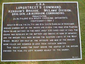
|


|
Although the author has taken all reasonable care in preparing this guide, Mapicurious and the author make no warranty about the accuracy or completeness of its content and accept no responsibility for any loss, injury, or inconvenience arising from its use. |